




All in one package for air, surface and subsea surveys
New integrated technology will bring unprecedented visibility for offshore construction, renewable, defence and other applications, provider Coda Octopus says.
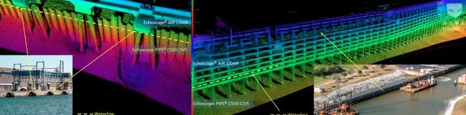
Coda Octopus is providing above, through and below the waterline capability by combining its real-time 3D Echoscope imaging sonar with its new Echoscope Air LiDAR Volumetric 3D Cameras.
The company says the true power of the new Air LiDAR is realised when coupled with any of its Echoscope volumetric sonars ‘to provide seamless real-time monitoring, mapping, and inspection, above, through and below the waterline’.
The Air LiDAR can be used independently as an above-water real-time 3D camera that is fully integrated into the Coda Octopus 4G USE software, and shares the same processing, real-time imaging and decision-making methodologies that are now well known across the industry.
The company claims that with the introduction and integration of the Air LiDAR, the new technology fusion will bring unprecedented visible capability to many construction, offshore-renewable, defence and specialist service provider applications and projects.
In addition to the real-time 3D imagery, angular and linear measurements can be made between any data points in the scene, from the Echoscope sonar, Air LiDAR or any industry standard 2D Chart and 3D Models inserted in the scene in real time. This level of real-time integration allows clear understanding, position and pose of assets being placed or surveyed.
Coda Octopus sees significant benefit and return for many key marine applications, including cable and pipelay applications in the offshore renewables sector.
Air LiDAR can for example provide cable catenary launch angle from the lay vessel above the water whilst the Echoscope sonar provides mid-water and seafloor touch-down point monitoring. Similarly, vertical placement of pilings and sheet pile can be monitored with a fused above and below dataset for straightness and tolerance during placement operations and before final commitment. These technologies and methodology are significantly different from the more traditional place, survey and rework approach often relied upon.
The company’s existing market penetration in the breakwater construction sector has been augmented by the introduction of the Air LiDAR as providing block placement and tracking above and below the water line on the berm, in addition to critical slope grading survey, which can now be conducted by the excavator or wire crane without the need for additional survey vessel and personnel.
Related Articles
 MARINE CIVILS
 MERGERS & ACQUISITIONS
 OTHER NEWS